
Purmamarca, Argentina: Altitude & Seven Colors Guide
Purmamarca sits at 2,192m in Jujuy. How to visit the Hill of Seven Colors, get there from Salta or Jujuy, and plan around altitude and crowds.
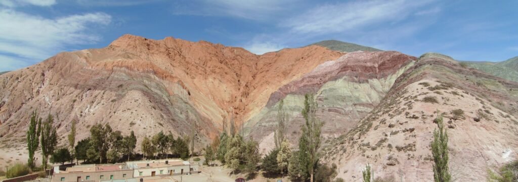
Purmamarca is a small adobe village at 2,192m in the Quebrada de Humahuaca, backed by the Cerro de los Siete Colores — a mountain whose bands of red, ochre, green and lavender come from millions of years of mineral sediment. It's the most photographed sight in northern Argentina and, for many travelers arriving from Salta, the first real "wow" of the trip.
The village itself is tiny — a plaza, a handicraft market, a handful of streets — and can be walked in under an hour. Most people treat it as a half-day stop on the way to Tilcara or Humahuaca, or as a base for the day trip out to the Salinas Grandes salt flats, which sit about an hour and a half up the mountain road.
Getting there
From San Salvador de Jujuy, it's about 65km north on RN9, roughly 1-1.5hr by car or remise; regular bus service runs between San Salvador de Jujuy, Tilcara and Purmamarca several times a day — check current timetables locally, as they shift. From Salta city, it's about 165km, roughly 2.5-3hr by car via RN9; many Salta-based tour agencies run day trips, though staying a night lets you see the village without the tour-bus crowds. No 4x4 is needed to reach the village itself — the paved highway runs right through it.
When to go
Purmamarca is a year-round destination, but April-June and September-November give the clearest light for photographing the hillside color bands (harsh midday sun tends to wash out the colors — early morning or late afternoon is better). December-March is the summer rainy season in the Quebrada; storms can be sudden and heavy, and road access and travel conditions toward Salinas Grandes can change. Winter nights (June-August) drop well below freezing even though days are mild and sunny — pack layers.
Altitude
The elevation shown is a reference point; the route may climb higher. Plan gradual ascent and seek individual medical advice before high-mountain travel. A suggested itinerary does not establish medical suitability. If symptoms appear, do not continue ascending; seek medical advice and descend if symptoms worsen. CDC guidance on altitude.
Practical notes
- Cash is still preferred at the handicraft market stalls around the plaza; card acceptance is improving in restaurants but don't count on it everywhere.
- Cell signal is generally reliable in the village itself but drops out on the roads to Salinas Grandes and the surrounding hills.
- Half a day is enough for the village and the short Paseo de los Colorados walking trail around the base of the hill; add a full day if you're doing Salinas Grandes from here.
- Bring sun protection — the altitude and thin air mean UV exposure is much stronger than it feels.
- The Sunday market is larger than the daily one; weekday afternoons are quieter if you want photos without crowds.
Frequently asked questions
Is Purmamarca worth an overnight stay or just a day trip?
Either works, but staying a night means you catch the hillside in the early morning and late afternoon light, and you avoid sharing the plaza with every tour bus from Salta that arrives midday.
Can I walk up the Cerro de los Siete Colores itself?
No — the hill is not open for hiking. The Paseo de los Colorados is a signed walking trail around its base, roughly 3km, that gives you close-up views without climbing the formation.
Do I need a rental car to see Purmamarca and Salinas Grandes together?
It's the easiest way — the salt flat road (RN52) has no regular public transit schedule from the village, so most travelers either rent a car, book a shared shuttle, or arrange a remise for the round trip.
Sources and how to use this guide
Trip organisation is an editorial suggestion. Confirm changing opening times, access and conditions with the relevant sources. References do not imply an on-site visit by our newsroom.
Report a correction →Make the trip work for you
Choose by trip length, compare bases, solve transport or start with a region. Each guide connects practical decisions with places and the trip planner.